Show the map
St-Martin-de-Brômes - Barrage de Gréoux
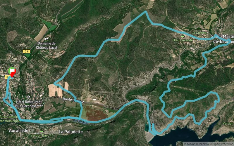


20.4 km
570 m
570 m
 Gréoux-les-Bains (04)
 Points of Interest table
| Accum. | Intermediary | |||||||
|---|---|---|---|---|---|---|---|---|
| POI | Description | Alt. | Dist. | D+ | D- | Dist. | D+ | D- |
Trace n°141074
Ascent threshold : 3 m Distance threshold : 30 m Smoothing : Yes Origin of altitudes : MNT Aster GDEM
Ascent threshold : 3 m Distance threshold : 30 m Smoothing : Yes Origin of altitudes : MNT Aster GDEM
Loop
Dominant terrain : Path
Max alti. : 519 m
Avg alti. : 385 m
Min alti. : 298 m
Longest ascent : 230 m
Longest descent : 200 m
Route completed by the author : No
Dominant terrain : Path
Max alti. : 519 m
Avg alti. : 385 m
Min alti. : 298 m
Longest ascent : 230 m
Longest descent : 200 m
Route completed by the author : No
Elevation profile
More tools
Create a new roadbook page
Map and track on your website
Warning ! When you insert a Trace de Trail map on your website, you agree not to hide any element of the module (links to Trail Trail or Trail Connect banner)
Add a realisation
Validate
Add a realisation to share your chrono and describe the conditions that you encountered during you trail running !
Add a comment
Validate
Urien Caroline Gael
10/06/21, 17:56:20
Merci Christophe pour ce tracé ! Beaucoup de pistes d'exploitation. La traversé au niveau du barrage est fermée. Donc retour par la route avec son flot de voitures ! Parcours réalisé en juin 2021
10/06/21, 17:56:20
Merci Christophe pour ce tracé ! Beaucoup de pistes d'exploitation. La traversé au niveau du barrage est fermée. Donc retour par la route avec son flot de voitures ! Parcours réalisé en juin 2021
Show the infos
Add a track